
onX Backcountry Launches Avalanche Terrain Exposure Scale (ATES) Classification and Mapping
December 7, 2023
onX is the first digital navigation app in the United States to include the ATES classification system, expanding its offering of avalanche safety tools
![]()
![]() MISSOULA, Mont., (December 7, 2023) /OUTDOOR SPORTSWIRE/ – onX Backcountry, a navigation and discovery app for outdoor enthusiasts, today launched a new mapping tool called the Avalanche Terrain Exposure Scale (ATES). ATES classifies terrain based on exposure to avalanches, helping snow enthusiasts–primarily backcountry skiers and snowboarders, as well as fat bikers, nordic skiers, and snowshoers–make more informed decisions regarding avalanche safety in the mountains.
MISSOULA, Mont., (December 7, 2023) /OUTDOOR SPORTSWIRE/ – onX Backcountry, a navigation and discovery app for outdoor enthusiasts, today launched a new mapping tool called the Avalanche Terrain Exposure Scale (ATES). ATES classifies terrain based on exposure to avalanches, helping snow enthusiasts–primarily backcountry skiers and snowboarders, as well as fat bikers, nordic skiers, and snowshoers–make more informed decisions regarding avalanche safety in the mountains.
According to Snowsports Industries of America’s 2022-23 participation report, close to 5 million backcountry skiers and boarders are heading into the mountains–a two-fold increase compared to pre-pandemic years. Participation in fat biking, nordic skiing, and snowshoeing have also hit record levels. Access to snow safety information for new entrants and seasoned adventurers is crucial to help keep powder seekers safe. To access this information, they turn to daily avalanche forecasts issued by the professional avalanche community to understand the day’s avalanche hazard and how to minimize their risk.
“The daily avalanche forecast considers numerous important variables, such as temperature, snowfall, slope aspect, and elevation,” said onX Backcountry Product Manager Charlie Avis. “Some of these variables change daily or even by the hour. But there is one variable that will likely remain the same throughout the season: terrain. That is where ATES comes in–helping a skier or snowboarder understand whether the terrain where they plan to ski or board could expose them to an avalanche, regardless if the daily avalanche forecast is low, moderate, considerable, or even extreme.”
Originally pioneered and developed by Parks Canada in 2003, ATES is a classification that assesses 11 different terrain inputs, including slope angle, starting zones, runout zones, forest density, and more. By working in tandem with Alaska-based researcher John Sykes, onX is bringing ATES in a digital format to the United States for the first time. Sykes’ algorithm (autoATES) analyzes terrain in popular winter regions in onX Backcountry.
To refine that algorithm, onX works with local avalanche forecasters to localize and verify ATES ratings, leveraging their local knowledge, expertise, and historical avalanche data. This human input is critical to ensure the layer’s accuracy. Furthermore, onX has partnered with American Avalanche Association (A3), American Institute for Avalanche Research and Education (AIARE), and the American Mountain Guides Association (AMGA) to ensure that ATES is a useful and valuable tool for the backcountry ski and snowboard audience.
“ATES is an important tool for all winter enthusiasts,” said Utah Avalanche Center’s director of forecasting, Mark Staples. “Taken together with the daily avalanche forecast, ATES can help the public–whether they’re a beginner or a professional–better understand how to reduce their overall risk, have an incredible time in the mountains, and get home to their friends and family at the end of the day.”
“onX Backcountry’s introduction of ATES, and its additional Avalanche Runout and Avalanche Potential Release Area layers, have the potential to greatly improve users’ risk management and backcountry navigation,” said American Avalanche Association executive director, Jayne Nolan. “It’s clear that onX is committed to providing innovation and improvement within the avalanche industry, cementing themselves as a leader within the digital mapping space.”
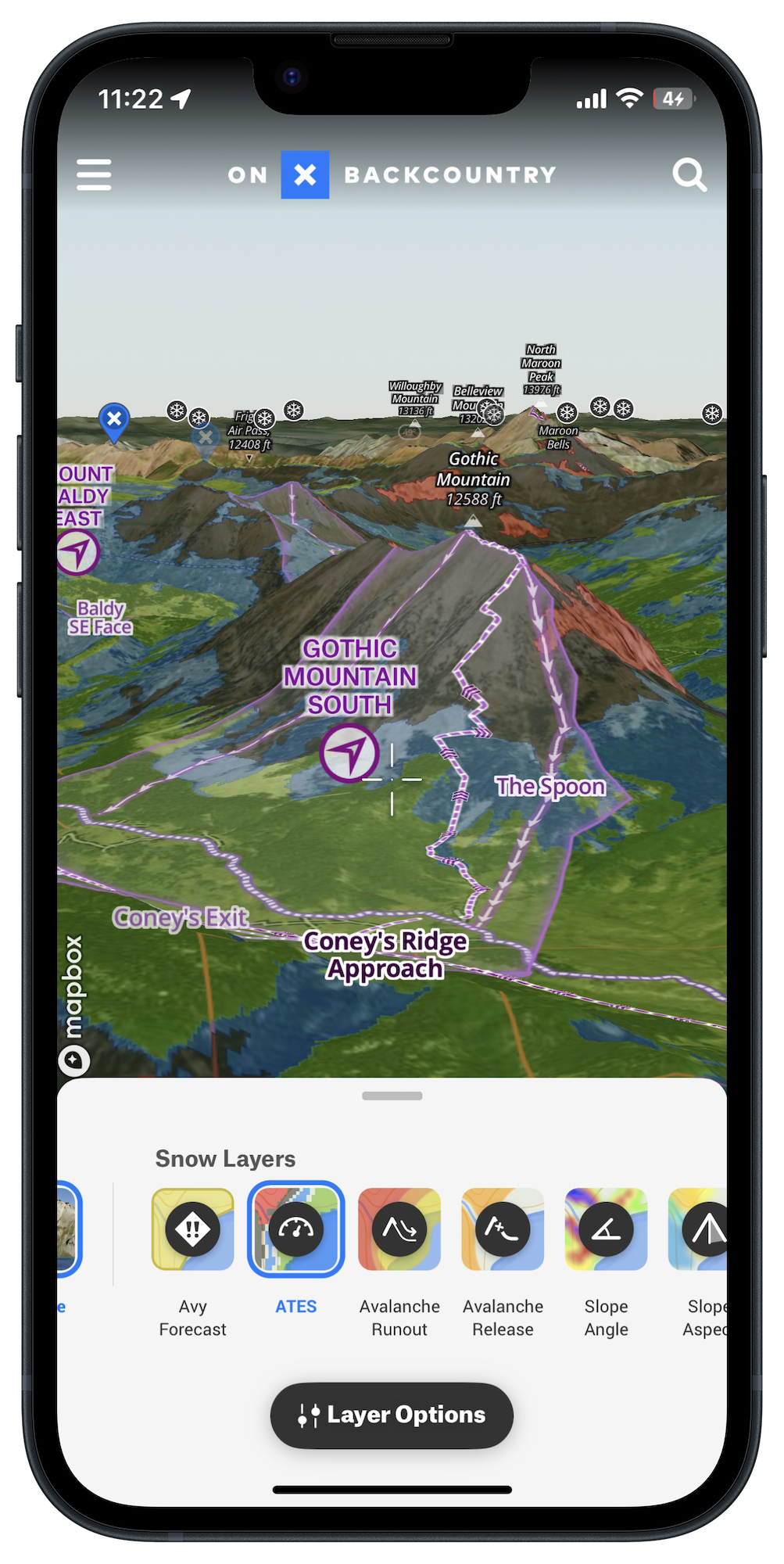
ATES is a layer in onX Backcountry’s robust Snow Mode that users can toggle on or off. It shows four different colors for four different ratings. Those ratings are: simple (green), challenging (blue), complex (black), and extreme (red). With this tool, users can connect the terrain to the daily avalanche forecast and confidently plan their adventure.
Because ATES is the result of 11 different inputs, some enthusiasts may enjoy seeing a few of those individually. To aid this understanding, onX has added an Avalanche Run Out layer and Avalanche Potential Release Area layer to Snow Mode for further exploration. App users can also toggle on other layers like the Daily Avalanche Forecast, Slope Aspect, and Slope Angle and access the weather forecast and SNOTEL data to expand their understanding of snow safety.
Current ATES coverage areas in the onX Backcountry app include zones in Colorado, Montana, and Utah. Coverage in additional regions will be added later this season, including Washington, California, Wyoming, and Alaska, as well as expanded regions in Colorado and Montana.
“ATES doesn’t tell you where to go,” says Beacon Guidebook founder and onX Backcountry senior content manager, Andy Sovik. “Winter outdoor enthusiasts still need to do the work to connect the forecast with the terrain and take critical avalanche safety education courses. But we are giving users the tools to apply this education right on the map.”
To learn more about ATES, and to purchase an onX Backcountry subscription, visit https://www.onxmaps.com/backcountry/app/features/avalanche-terrain-exposure-scale
About onX Backcountry
onX Backcountry empowers trailblazers and powder seekers of all levels to find new outdoor experiences and relive old favorites. Unlike other apps on the market, onX Backcountry combines industry-leading GPS tools with expert-curated adventure content. Members can enjoy access to 770K+ trails and 30,000+ guide-book adventures. Because off-the-beaten-path experiences are at the heart of what onX does, the company also leads initiatives to protect and expand access to public land and promote stewardship opportunities. Learn more at https://www.onxmaps.com/onx-access-initiatives
onX Backcountry Launches Avalanche Terrain Exposure Scale (ATES) Classification and Mapping
onX is the first digital navigation app in the United States to include the ATES classification system, expanding its offering of avalanche safety tools
MISSOULA, Mont., (December 7, 2023) — onX Backcountry, a navigation and discovery app for outdoor enthusiasts, today launched a new mapping tool called the Avalanche Terrain Exposure Scale (ATES). ATES classifies terrain based on exposure to avalanches, helping snow enthusiasts–primarily backcountry skiers and snowboarders, as well as fat bikers, nordic skiers, and snowshoers–make more informed decisions regarding avalanche safety in the mountains.
According to Snowsports Industries of America’s 2022-23 participation report, close to 5 million backcountry skiers and boarders are heading into the mountains–a two-fold increase compared to pre-pandemic years. Participation in fat biking, nordic skiing, and snowshoeing have also hit record levels. Access to snow safety information for new entrants and seasoned adventurers is crucial to help keep powder seekers safe. To access this information, they turn to daily avalanche forecasts issued by the professional avalanche community to understand the day’s avalanche hazard and how to minimize their risk.
“The daily avalanche forecast considers numerous important variables, such as temperature, snowfall, slope aspect, and elevation,” said onX Backcountry Product Manager Charlie Avis. “Some of these variables change daily or even by the hour. But there is one variable that will likely remain the same throughout the season: terrain. That is where ATES comes in–helping a skier or snowboarder understand whether the terrain where they plan to ski or board could expose them to an avalanche, regardless if the daily avalanche forecast is low, moderate, considerable, or even extreme.”
Originally pioneered and developed by Parks Canada in 2003, ATES is a classification that assesses 11 different terrain inputs, including slope angle, starting zones, runout zones, forest density, and more. By working in tandem with Alaska-based researcher John Sykes, onX is bringing ATES in a digital format to the United States for the first time. Sykes’ algorithm (autoATES) analyzes terrain in popular winter regions in onX Backcountry.
To refine that algorithm, onX works with local avalanche forecasters to localize and verify ATES ratings, leveraging their local knowledge, expertise, and historical avalanche data. This human input is critical to ensure the layer’s accuracy. Furthermore, onX has partnered with American Avalanche Association (A3), American Institute for Avalanche Research and Education (AIARE), and the American Mountain Guides Association (AMGA) to ensure that ATES is a useful and valuable tool for the backcountry ski and snowboard audience.
“ATES is an important tool for all winter enthusiasts,” said Utah Avalanche Center’s director of forecasting, Mark Staples. “Taken together with the daily avalanche forecast, ATES can help the public–whether they’re a beginner or a professional–better understand how to reduce their overall risk, have an incredible time in the mountains, and get home to their friends and family at the end of the day.”
“onX Backcountry’s introduction of ATES, and its additional Avalanche Runout and Avalanche Potential Release Area layers, have the potential to greatly improve users’ risk management and backcountry navigation,” said American Avalanche Association executive director, Jayne Nolan. “It’s clear that onX is committed to providing innovation and improvement within the avalanche industry, cementing themselves as a leader within the digital mapping space.”
ATES is a layer in onX Backcountry’s robust Snow Mode that users can toggle on or off. It shows four different colors for four different ratings. Those ratings are: simple (green), challenging (blue), complex (black), and extreme (red). With this tool, users can connect the terrain to the daily avalanche forecast and confidently plan their adventure.
Because ATES is the result of 11 different inputs, some enthusiasts may enjoy seeing a few of those individually. To aid this understanding, onX has added an Avalanche Run Out layer and Avalanche Potential Release Area layer to Snow Mode for further exploration. App users can also toggle on other layers like the Daily Avalanche Forecast, Slope Aspect, and Slope Angle and access the weather forecast and SNOTEL data to expand their understanding of snow safety.
Current ATES coverage areas in the onX Backcountry app include zones in Colorado, Montana, and Utah. Coverage in additional regions will be added later this season, including Washington, California, Wyoming, and Alaska, as well as expanded regions in Colorado and Montana.
“ATES doesn’t tell you where to go,” says Beacon Guidebook founder and onX Backcountry senior content manager, Andy Sovik. “Winter outdoor enthusiasts still need to do the work to connect the forecast with the terrain and take critical avalanche safety education courses. But we are giving users the tools to apply this education right on the map.”
To learn more about ATES, and to purchase an onX Backcountry subscription, visit https://www.onxmaps.com/backcountry/app/features/avalanche-terrain-exposure-scale
About onX Backcountry
onX Backcountry empowers trailblazers and powder seekers of all levels to find new outdoor experiences and relive old favorites. Unlike other apps on the market, onX Backcountry combines industry-leading GPS tools with expert-curated adventure content. Members can enjoy access to 770K+ trails and 30,000+ guide-book adventures. Because off-the-beaten-path experiences are at the heart of what onX does, the company also leads initiatives to protect and expand access to public land and promote stewardship opportunities. Learn more at https://www.onxmaps.com/onx-access-initiatives
Company Info
onx Backcountry
CONTACT INFO
Kelly Becker
8178001939
kelly@bfcollective.co
www.onxmaps.com/backcountry/app
Follow us on